NL

The Netherlands in 3D

Explore and experience the Netherlands in 3D

Explore the Netherlands in an interactive 3D environment, add map layers, create projects and experience the surroundings in VR and AR.

About 3DCityTour

Explore the Netherlands in 3D and bring your ideas to life

With you can explore the Netherlands in an interactive 3D environment. Explore buildings and map layers, study shadows and solar potential, or add your own 3D models to visualize plans for a location.

Use 3DCityTour directly in your browser on a desktop, phone, or tablet. On supported devices you can also experience the environment in Virtual Reality (VR) and Augmented Reality (AR). Exploring the Netherlands in 3D is free. Plus and Pro offer additional features for projects and cloud storage.

Discover 3DCityTour

Videos

A selection of videos showcasing what you can do with 3DCityTour.

Getting started

How do you use 3DCityTour?

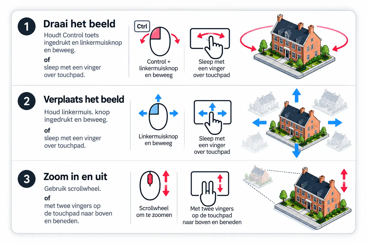
Select your device to learn the controls. Short tutorial videos will be added here.

What can you do with 3DCityTour?

Digital Twin

The 3D components in this application are generated automatically from open data. These datasets are continuously improved, and the web application is still under active development.
The 3D buildings are based on the 3DBAG dataset from TU Delft. Trees are placed automatically using BGT data. The aerial photography comes from PDOK with a resolution of 8 cm per pixel, and the terrain model is based on AHN3.
The application also includes a sample area in Rotterdam. The municipality invests heavily in its 3D city model (digital twin) and provides highly detailed 3D buildings, making Rotterdam an excellent example.

This site uses open-source WebXR libraries to display 3D experiences in the browser. Although modern browsers can access device CPU and GPU resources through WebGL or WebGPU, they still face limitations. Browser security layers, sandboxing and rendering overhead make it more challenging to deliver large, detailed 3D environments at the same performance as specialized native engines such as Unity or Unreal Engine.

The advantage of browser-based WebXR is that it makes immersive experiences accessible to everyone.
The challenge is finding the right balance between visual quality and accessibility.

Choose the right plan for you

Subscriptions

Explore the Netherlands in 3D with Free. Choose Plus or Pro for larger uploads, cloud projects and Open Urban Platform synchronization.

Beta period until 1 January 2027: Plus is free during the beta period, and Pro is unavailable until then. From 1 January 2027, Plus costs €19.95 per month and Pro costs €29.95 per month.

Compare Free, Plus, Pro and custom plans
Feature Free Plus Pro Custom
Monthly price Free € 19,95
Free during beta until 1 January 2027
€ 29,95
Available from 1 January 2027
Custom
Availability Available Available as a free beta From 1 January 2027 Contact us
Explore the Netherlands in 3D Yes Yes Yes Yes
Virtual Reality Yes Yes Yes Yes
Add your own map layers Yes Yes Yes Yes
Browse the Open Urban Platform catalogue Yes Yes Yes Yes
Browse the PDOK catalogue Yes Yes Yes Yes
Shadow simulation Yes Yes Yes Yes
Assess solar potential Yes Yes Yes Yes
Projects with 3D models Yes Yes Yes Yes
Export as 3D Tiles No Yes Yes Yes
Projects with pins Yes Yes Yes Yes
Export as GeoJSON No Yes Yes Yes
Save projects in the cloud No Yes Yes By arrangement
Synchronize with Open Urban Platform No Yes Yes By arrangement
Total cloud storage 100 MB 1 GB 5 GB By arrangement
Suitable for Exploring the Netherlands and trying uploads Creating and saving your own projects Your own projects with more storage More storage or specific requirements
  • Free — explore the environment

    Explore the Netherlands in 3D and try adding your own files. You receive 100 MB of total storage.

  • Plus — work on your own projects

    €19.95 per month. Free during the beta until 1 January 2027.

    You receive 1 GB of total storage for your own files and projects. Save projects to the cloud, export as 3D Tiles or GeoJSON, and synchronize with the Open Urban Platform (OUP).

  • Pro — for your own projects

    €29.95 per month. Available from 1 January 2027.

    All Plus features, with 5 GB of total storage.

  • Custom — discuss your requirements

    Need more storage or specific project features? Contact us to discuss your requirements and a tailored offer.

    Discuss your requirements

Open Urban Platform: 3DCityTour integrates with OUP. Synchronization requires an OUP account and access to the relevant environment. Any OUP fees are separate from your 3DCityTour subscription.

Help & guidance

Frequently asked questions

The information, data, maps, 3D models, visualizations and other content provided through 3DCityTour.nl are intended solely for general information, visualization and demonstration. 3DCityTour.nl is a service provided by UrbanPixels.

Accuracy and completeness

UrbanPixels takes care in developing and operating the service, but cannot guarantee that information is complete, accurate, up to date or suitable for a particular purpose. Content may come from public datasets, external services and third parties and may contain errors, omissions or outdated information, including errors in the software's calculations. Actual conditions may differ from the displayed buildings, objects, terrain, elevations, aerial photographs, maps and 3D models. No rights can be derived from these representations.

Professional decisions

3DCityTour.nl is not an official or legally binding source. Information must not be used without independent verification for construction, legal, planning, financial, safety, surveying or other professional decisions. Users are responsible for consulting the original or competent authority before making decisions or carrying out work.

Liability

Use of the website and its features is entirely at your own risk. To the extent permitted by law, UrbanPixels accepts no liability for direct or indirect loss arising from using or being unable to use the service; reliance on data, maps, 3D models or visualizations; inaccurate, incomplete or outdated information; differences from actual conditions; interruptions, errors or temporary unavailability; or loss of data and consequential damage. This also applies to damage connected with third-party data, software, services or information.

Availability and changes

UrbanPixels does not guarantee uninterrupted or error-free availability. The service depends in part on third-party data sources, servers and APIs outside its control. UrbanPixels may change, expand, suspend or remove features or content at any time without prior notice.

External links and services

Links to third-party websites and services do not imply endorsement. UrbanPixels does not control their content, security, operation or availability and gives no guarantee of their accuracy, completeness, reliability or currency.

Privacy and cookies

Technically necessary data and cookies are used to operate and secure the website and its services unless otherwise stated. Search queries are recorded for analysis.

Intellectual property and data sources

Copyright, database rights, license terms and other rights belonging to UrbanPixels or third parties may apply to the data, maps, 3D models and images. Displaying content does not mean it may be copied, redistributed or reused without restrictions. Third-party reuse is governed by the source's terms.

Final provisions

By using 3DCityTour.nl, you acknowledge that digital maps and models may simplify reality or be outdated, and you use them at your own risk. To the extent permitted by law, UrbanPixels is not liable for damage connected with use of the website, its information or services.

Yes. Open the layers menu (stacked squares), select “Add your own 3D Tileset”, and enter your Cesium access token and asset ID.

A digital twin is a digital representation of a physical place, such as a city or building. It lets people explore and analyze environments in 3D, often with interactive features and live data. Public authorities and businesses can use digital twins for planning, education, tourism and visualizing future developments.

The Open Urban Platform by Future Insight provides an international catalog of urban datasets, including 3D Tilesets and digital twins. You can browse this catalog directly in 3DCityTour and add available datasets to your experience. Learn more at Open Urban Platform (Clearly.Hub).

3DCityTour supports 3D Tiles, XYZ, TMS, GeoJSON, WMTS and WMS. Some variants may not work in every case. 3D Tiles are commonly used for buildings, trees and other 3D objects; XYZ and TMS for raster maps; GeoJSON for points, lines and polygons; and WMTS/WMS for web map services.

3DCityTour.nl is designed for everyone interested in exploring cities, neighborhoods and digital twins in the Netherlands, not just GIS or 3D professionals.

Although the application is continually improving, crashes can still occur. Try refreshing the page (F5 or Ctrl+R), closing other tabs to free memory, and reducing the “Detail” slider in the upper-right corner. Fewer objects may appear at a distance, but nearby buildings should load as you zoom in or enter VR.

Check that the appropriate map layers are enabled and zoom in. Buildings are loaded dynamically. If necessary, increase the Detail slider to load more objects. Higher detail requires more memory and processing power and may reduce performance, particularly in VR.

Yes. The default is 2 metres. Adjust “Headset Height (m)” in the settings, for example to 1.2 metres or 40 metres for a higher viewpoint.

Yes. Open the layers menu and choose “Add your own map layer”. Enter the URL of your Tileset or select one from a catalog. Supported Cesium 3D Tiles formats include implicit/explicit tiling and b3dm, glb, i3dm and cmpt. The URL must point to tileset.json. The host must enable Cross-Origin Resource Sharing (CORS) so the browser can fetch the Tileset.

The Open Urban Platform (Clearly.Hub) by Future Insight is a catalog for urban data, including 3D Tilesets. You can browse it and add available datasets directly from 3DCityTour.

PDOK (Public Services on the Map) provides central access to Dutch government geospatial datasets and services. You can explore the PDOK catalog within 3DCityTour.

Municipalities and provinces increasingly publish 3D models as 3D Tilesets. 3DCityTour includes examples from several places. Rotterdam is featured for its detailed 3D buildings; additional Dutch models and BGT trees have also been made available through 3dtilesnederland.nl.

Yes, on modern phones and tablets. WebXR-based AR is available on supported Android devices with Chrome or Edge. Safari on iOS does not currently support this AR mode; a beta Mozilla WebXR Viewer may provide an alternative.

AR overlays 3D models on the real-world camera view. Select “My Location” and allow access to location and camera, or search for an address and tap the AR button to explore that location in Mixed Reality.

A texture is an image applied to a 3D object to make it look more realistic. Textures can be used on buildings, trees and other models.

A mesh is a 3D surface made from small polygons. Adding photographic textures creates a realistic representation of a city or landscape. Individual buildings or trees in a mesh often cannot be selected independently. 3DCityTour also focuses on separate 3D objects with their own attributes that can be selected and inspected.

Color themes and ColorMaps change how 3D objects are displayed. You can create and add ColorMaps as layers and share datasets through the Open Urban Platform. See the ColorMap template and the Energy Label ColorMap, which colors buildings according to their energy rating.

Yes. Place your phone in a compatible Cardboard headset and select the Cardboard icon in the menu. For the best experience, use your browser’s full-screen mode or hide its controls.

Not all browsers support WebXR. Chrome or Edge are recommended on supported devices. Safari on iOS does not currently support this WebXR AR mode; a beta Mozilla WebXR Viewer may offer an alternative.

To keep the website responsive, 3D objects are streamed as needed. More buildings, trees and other objects appear as you move or zoom in. Increase the Detail slider to load more objects, bearing in mind that this uses more memory and can affect performance.

Yes. Change the sun position and intensity in the settings menu to simulate different lighting conditions.

Yes. Use the shadow analysis feature in the settings menu to simulate shadows based on the sun’s position. This can help visualize the effects of buildings on sunlight in urban areas.

Yes. Cookies help remember preferences and caching helps load previously accessed content faster. You can disable them in your browser, but some features or performance may be affected.

Enable or disable caching in the application settings. Caching stores previously loaded 3D data locally to speed up repeat visits. It uses device storage, and you may need to clear the cache when a provider publishes updated data.

Roof orientation

Roof orientation is an important factor in solar potential. South-facing roofs generally receive more sunlight than north-facing roofs. The orientation display uses warmer colors for south-facing and cooler blue colors for north-facing roofs. Enable the analysis in settings.

Hespul

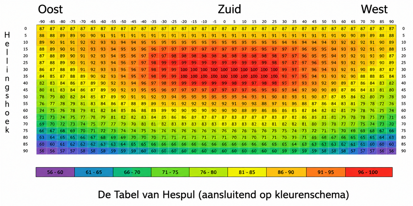
The Hespul method estimates relative solar potential based on a roof surface’s direction and pitch. Higher values indicate more favorable conditions for solar panels.

Hespul solar potential table

Some layers depend on other layers. For example, a building energy-label ColorMap requires the 3D buildings layer. 2D layers require terrain. Click the yellow warning icon to see which dependencies must be enabled.

Some features require specific settings or datasets. For example, outlining 3D objects requires a compatible object layer. Click the yellow warning icon to see what is missing.

Check that the correct terrain model is selected. Differences in accuracy, age or vertical reference systems can make buildings appear to float or sink.

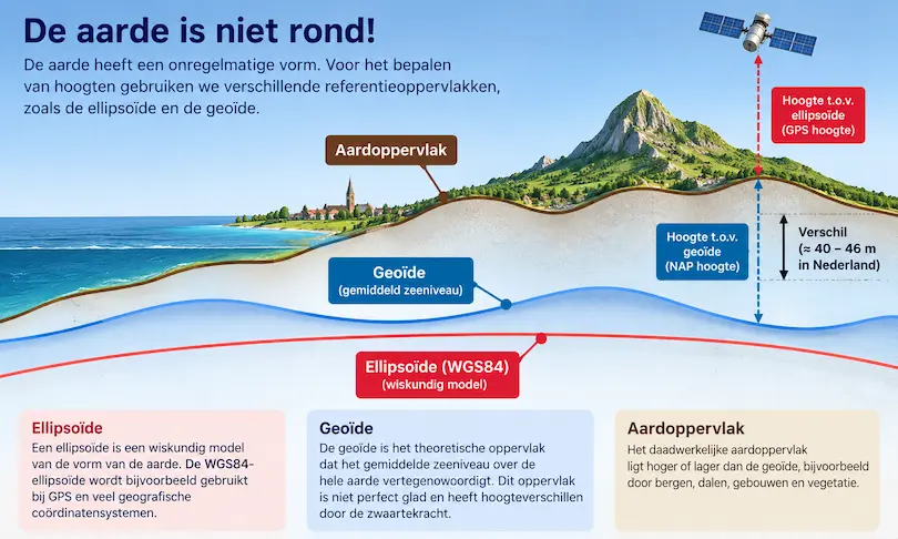
The Earth is not a perfect sphere

An ellipsoid is a mathematical approximation of Earth’s shape, while the geoid approximates mean sea level and varies with gravity. These are different height reference surfaces.

Ellipsoid, geoid and Earth surface
The ellipsoid and geoid provide different reference surfaces for heights.

What does this mean in the Netherlands?

Heights are commonly expressed relative to Normaal Amsterdams Peil (NAP). NAP is related to, but not identical to, the geoid. In the Netherlands, WGS84 ellipsoidal heights differ from NAP heights by roughly 40–46 metres. Combining these without the correct conversion can cause major vertical offsets.

Which reference does 3DCityTour use?

Original Dutch source data, including 3DBAG, often uses RD New + NAP (EPSG:7415). Other datasets may use WGS 84 (EPSG:4979) or different systems. Terrain and 3D Tilesets must use compatible height references. Switching terrain models may help; otherwise, a vertical transformation may be required.

Yes. Since version 7.5 you can add and move objects in the 3D environment. Save collections as projects locally, exchange them as files, or store them in the cloud.

A project stores the objects and settings you create or change in 3DCityTour. You can save and reopen projects to continue working, and use supported sharing or cloud options.

Draco is a geometry compression technology that can reduce the size of 3D model data and improve transfer efficiency.

What should you consider?

Draco compresses geometry such as vertex positions and attributes, not texture images. Decoding requires processing time, so loading is not always faster.

Viewer support

The 3D viewer must support Draco-compressed geometry. Check compatibility before publishing or sharing compressed 3D Tilesets.

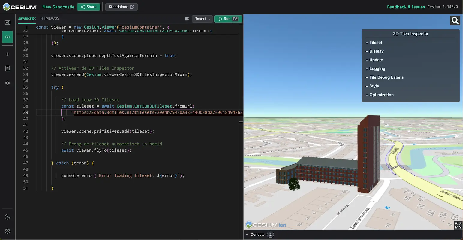
Yes. Open Cesium Sandcastle, copy the sample code below, replace the existing JavaScript code and change URL_VAN_JOUW_3D_TILESET to your public tileset.json URL. Then click Run.

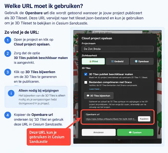
Find the public URL in 3DCityTour’s “Save cloud project” dialog. Enable “Make 3D Tiles publicly available” and use “Update 3D Tiles” after changing the project.

URL_VAN_JOUW_3D_TILESETtileset.json
Het venster Cloud project opslaan in 3DCityTour.nl, met de openbare URL van de 3D Tileset gemarkeerd.
The public URL of a 3D Tileset in 3DCityTour.nl. Use the Copy button to copy the URL. Registration in the Open Urban Platform is optional.
Het venster Cloud project opslaan in 3DCityTour.nl, met de openbare URL van de 3D Tileset gemarkeerd.

            const viewer = new Cesium.Viewer("cesiumContainer", {
                animation: false,
                baseLayerPicker: false,
                fullscreenButton: true,
                vrButton: false,
                geocoder: true,
                homeButton: false,
                infoBox: false,
                selectionIndicator: true,
                timeline: false,
                shadows: false,
                navigationHelpButton: false,
                navigationInstructionsInitiallyVisible: true,
                scene3DOnly: true,
                shouldAnimate: false,
                baseLayer: new Cesium.ImageryLayer(
                    new Cesium.UrlTemplateImageryProvider({
                        url: "https://{s}.tile.openstreetmap.org/{z}/{x}/{y}.png",
                        maximumLevel: 19
                    })
                ),
                terrainProvider: await Cesium.CesiumTerrainProvider.fromUrl(
                    "https://www.nederlandin3d.nl/viewer/datasource-data/882a9596-4d32-479a-a130-33cfbc713696",
                    {
                        requestVertexNormals: true
                    }
                )
            });

            viewer.scene.globe.depthTestAgainstTerrain = true;

            // Activeer de 3D Tiles Inspector
            viewer.extend(Cesium.viewerCesium3DTilesInspectorMixin);

            try {

                // Laad jouw 3D Tileset
                const tileset = await Cesium.Cesium3DTileset.fromUrl(
                    "URL_VAN_JOUW_3D_TILESET"
                );

                viewer.scene.primitives.add(tileset);

                // Breng de tileset automatisch in beeld
                await viewer.flyTo(tileset);

            } catch (error) {

                console.error(`Error loading tileset: ${error}`);

            }

              
Cesium Sandcastle met een geladen 3D Tileset
Example of a 3D Tileset displayed in Cesium Sandcastle.
Cesium Sandcastle met een geladen 3D Tileset

Yes. 3DCityTour supports open standards from the Open Geospatial Consortium (OGC) to exchange geospatial data and models.

Pin projects and GeoJSON

Export marked locations, titles and descriptions as GeoJSON for use in other map applications.

3D projects and OGC 3D Tiles

Publish your 3D models as an OGC 3D Tileset with a public URL for compatible viewers. The receiving viewer must support the relevant 3D Tiles version and compression.

What is the difference?

A project stores editable work in 3DCityTour. GeoJSON exchanges geographic locations and attributes. OGC 3D Tiles publishes 3D models for external viewers. Exported formats do not automatically preserve every project-specific setting or editing capability.

Sources and software components

The main sources and components are:

Partner websites

Reach the right audience

Advertise on 3DCityTour

Introduce your business to visitors interested in their homes, properties or local environment.

Are you a business owner?

Could your products or services be valuable to visitors of 3DCityTour.nl?

3DCityTour attracts thousands of visitors and offers ways to reach people searching in a specific region or interested in a particular subject.

Examples include solar panels, shading systems, home improvements, building opportunities and landscaping.

Interested? Contact us to discuss the possibilities without obligation.

Contact us

We'd love to hear from you

Contact

Do you have a question about 3DCityTour.nl, an improvement suggestion or a problem to report? Let us know.

You can also contact us about your own 3D models, projects, subscriptions or potential collaborations.

3DCityTour.nl is an initiative of UrbanPixels.

Email: info@3dcitytour.nl

Send an email

Disclaimer

3DCityTour.nl is a service provided by UrbanPixels that lets you explore the Netherlands in 3D, create projects and visualize possible changes to the environment. Available features and storage capacity depend on your subscription.

Maps, 3D models and other data come from public sources, external services and user uploads. The data and calculations may contain inaccuracies or be outdated.

Visualizations, shadow simulations and solar potential calculations are intended to provide insight. They do not replace official information, measurements or professional advice. Verify relevant data with the original or competent source before making decisions.

UrbanPixels takes care in developing and operating 3DCityTour.nl. Maintenance, outages and third-party service availability may temporarily affect operation. See the terms in the FAQ for more information. Terms in the frequently asked questions.

Questions or comments about 3DCityTour.nl? See our contact details.

Virtual tours available in: Amsterdam, Rotterdam, Utrecht, The Hague, Eindhoven, Groningen, Maastricht.